(11) Vela Luka, Ubli, Slano, Koločep, Komolac, Gruž, Vis, Cavtat, 21 June 1978
This is the most pronounced event observed in the Adriatic Sea so far and is therefore one of the most studied. The basic data on sea-level variability in Vela Luka are provided by Orlić (1980), who carried out interviews with eyewitnesses between 16 and 20 June 1980. The information on the phenomenon as it was observed not only in Croatian towns but also in Italian towns is contained in numerous newspaper articles, a collection of which was published by Vučetić and Barčot (2008).
Based on all these observations, Orlić et al. (2010) prepared a map showing both the wave heights and onset times. Also included in the map is information extracted from the available tide-gauge measurements.
It is obvious that tide gauges recorded an intensification of high-frequency sea-level variability, but they did not register the maxima observed by eyewitnesses due to the local nature of the phenomenon. An additional problem with the tide-gauge records was that they had to be inspected visually because the instruments operating in 1978 were analog and the high-frequency signals were blurred in their records.
The cause of the event was studied on several occasions, which resulted in four hypotheses regarding the generating mechanism. Two of the hypotheses identified the cause to be at the sea bottom: Zore-Armanda (1979) related the event to an earthquake that occurred the day before in the Aegean Sea area, whereas Bedosti (1980) connected it with a landslide that presumably occurred off the middle Adriatic coast of Italy.
The other two hypotheses placed the cause in the atmosphere: Hodžić (1979, 1988) attributed the event to free waves impulsively generated in the open Adriatic by a cyclone, whereas Orlić (1980) related it to forced waves resonantly driven by an atmospheric gravity wave.
Only the last of these hypotheses was supported by a comprehensive modeling effort (Orlić et al., 2010), which showed that small air-pressure forcing could have produced sea-level variability in Vela Luka reaching a few meters and thus surpassing the inverted barometer response by two orders of magnitude. High spatial variability of sea level heights in the inner part of the bay was observed during the Vela Luka flood. This variability was successfully modelled only upon adding flooding and drying processes to the model (Bubalo, 2019; Bubalo, 2021).
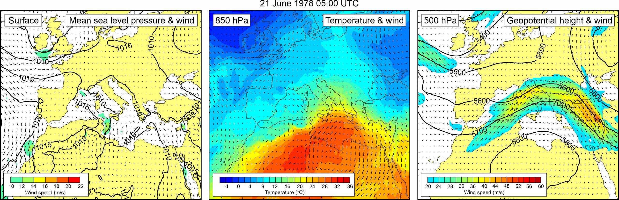
The synoptic setting (also analysed in Vučetić et al., 2009 and Vilibić and Šepić, 2009) was typical for the Adriatic meteotsunami events. Relatively uniform mean sea level pressure field, with no pronounced surface winds, was present over most of Europe. At the 850 hPa level, warm air was advancing from the northern Africa, across the eastern Mediterrranean and the Adriatic Sea. As a result, an upper level temperature front developed over the Adriatic Sea. At the 500 hPa level, a ridge was located over the Mediterranean. Its rear side was placed right across the Adriatic Sea resulting with strong southwesterly to westerly mid-tropospheric winds (up to ~40 m/s) blowing over the Adriatic Sea.