Episode 7, 3 November 1968
Analysis
Description
Meteorological background
On 31 October, the weather over the Mediterranean and the Adriatic was under influence of an upper-level ridge accompanied by surface air pressure around 1020 hPa, while an uupper-level trough was present over the Atlantic, with a surface-based cyclone with central pressure of 985 hPa. Over the next three days, the trough and cyclone moved eastward. By 3 November, the upper-level flow over the Adriatic became southerly, and a secondary surface cyclone from the Gulf of Lion advanced eastward. This progression caused moderate southeasterly winds on 31 October, which intensified to strong and gale-force by 2 November and in early 3 November.
Sea-level evolution
On 3 November 1968, at 06:00 UTC, the sea level in Bakar reached 90 cm above the long-term average. The overall sea-level maximum coincided with the daily tidal peak; therefore, tide contributed 25 cm. The period before the flood was calm, and the final cyclone was isolated, so no previously triggered basin-wide oscillations (~21.2 hours) were present in the Adriatic. Synoptic component was mainly driven by a storm surge caused by several days of Sirocco winds. Starting around 31 October, moderate southeast winds began accumulating water at the basin’s closed end, intensifying over time. Synoptic component contributed 34 cm to the overall sea-level maximum.
The remaining sea-level rise resulted from processes acting on other time scales (refer to Figure 1 in the Introduction for detailed explanations). High-frequency oscillations added 9 cm, planetary-scale variability added 15 cm, and long-term sea-level change contributed 7 cm.
This episode was the result of fine tuning of all involved processes.
Newspapers
Here are excerpts from reports about the flood from Novi list.
Novi list, 4 November 1968
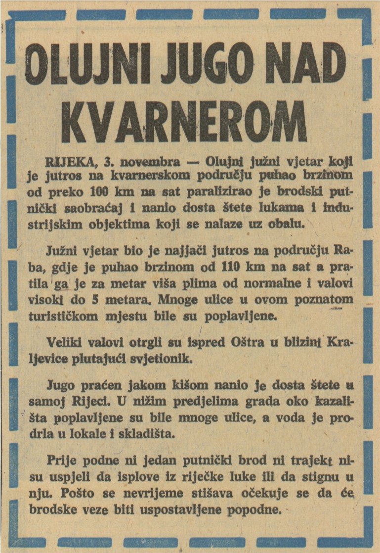
Stormy Sirocco over Kvarner
RIJEKA, 3 November – A stormy Sirocco blowing at over 100 km/h this morning paralyzed maritime traffic in the Kvarner region and caused considerable damage to ports and industrial facilities along the coast.
The Sirocco was strongest this morning in the Rab area, where it blew at a speed of 110 km/h, accompanied by a tidal wave one meter higher than normal and waves up to 5 meters high. Many streets in this well-known tourist resort were flooded.
Huge waves swept away a floating lighthouse near Oštra.
The Sirocco, which was accompanied by heavy rain, caused considerable damage in Rijeka itself. Many streets in the lower part of the city around the theater were flooded, and water entered stores and warehouses.
No passenger ships or ferries were able to leave or reach the port of Rijeka this morning. As the storm subsides, it is expected that shipping services will be restored this afternoon.
Novi list, 4 November 1968
Strong Sirocco in the Vinodol Channel.
CRIKVENICA, 3 November – The strong Sirocco blowing over the Adriatic reached the Vinodol Channel last night and caused considerable material damage. The sea rose to the height of the coast itself, and large waves, which met with no resistance, occasionally lapped against the shore. The storm caused concern for the owners of many boats and fishing vessels, who had to reinforce their moorings in the harbor. The large waves destroyed part of the protective wall at the breakwater in the port of Crikvenica and caused considerable damage to the beaches. The Petaka area was flooded and traffic had to be diverted.
The parks along the coast were also damaged. The intensity of the wind and waves decreased significantly in the afternoon.

