STORM SURGES IN THE ADRIATIC SEA
Catalogue of the floods in the Adriatic Sea
Adriatic floods
Exceptionally high sea levels (in periods of more than two hours) occasionally occur in the Adriatic Sea, especially in autumn and winter, causing flooding and significant damage along the coast (e.g., Međugorac et al., 2015, 2016; Lionello et al., 2021).
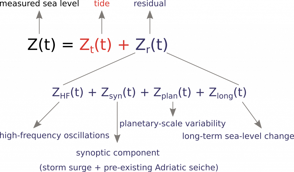
This phenomenon is caused by a positive superposition of several processes (Figure 1), the most important of which are storm surges, tides and sea-level variations on planetary scale (Šepić et al., 2022). Other processes that can support the formation of exceptionally high sea levels and usually make a smaller contribution than the three processes already mentioned are: high-frequency oscillations (modes of harbour/bay seiches; Ruić et al., 2023), pre-existing Adriatic-wide seiches (period ~21.2 hours; Cerovečki et al., 1997) and long-term sea-level change in periods longer than 100 days (seasonal cycle, (inter)annual and (multi)decadal changes, secular change).
Figure 1 shows sea-level series decomposed into different processes: tide (Zt) calculated by harmonic analysis/synthesis and other processes determined from the residual (de-tided sea level; Zr) by applying a digital filter.

Figure 1. Decomposition of sea level into different processes. The tide (Zt) was calculated as the sum of the Adriatic seven major constituents (K1, O1, P1, K2, S2, M2, N2). Other components were calculated from the residual (Zr) using the Kaiser-Bessel filter: high-frequency oscillations (ZHF; 2 h – 9 h), synoptic component (Zsyn; 9 h – 10 d), planetary-scale variability (Zplan; 10 – 100 d) and long-term sea-level change (Zlong; 100 d <).
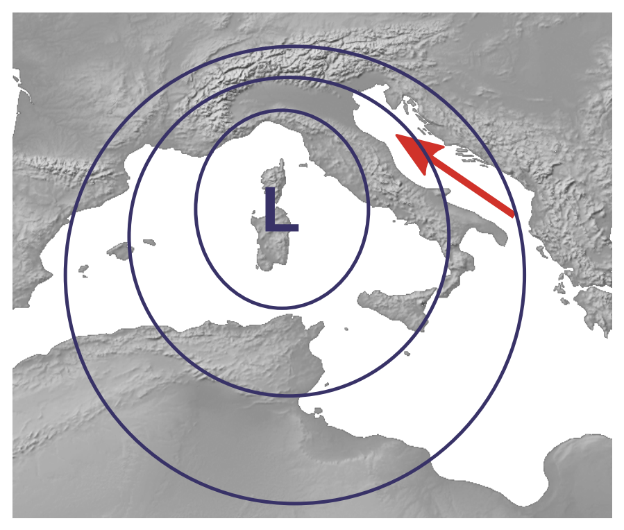
Storm surges are the main contributor to flooding in the northern Adriatic. They are formed when Mediterranean cyclones move across the Adriatic, causing an air-pressure gradient and a southerly wind Sirocco (Figure 2) (Trigo and Davies, 2002). Depending on the location of the cyclone, the sea-level response can be stronger along the eastern or the western coastline (Međugorac et al., 2018).

Figure 2. Illustration of the atmospheric conditions that favour the formation of storm surges in the Adriatic Sea. The blue curves indicate isobars, while the red arrow represents the Sirocco wind. The illustration was created with Natural Earth (https://www.naturalearthdata.com).
The tides in the Adriatic Sea are of a mixed type, consisting mainly of three diurnal (K1, O1, P1) and four semi-diurnal (K2, S2, M2, N2) constituents. The amplitude of the tidal signal increases towards the closed end of the basin, where it reaches values above 0.5 m (Janeković and Kuzmić, 2005).
Planetary-scale variability is a response of sea level to different drivers of which the most important are atmospheric planetary waves (Rossby waves) that occur in the middle troposphere (500 hPa) with periods of 10 – 100 days (Pasarić et al., 2000).


