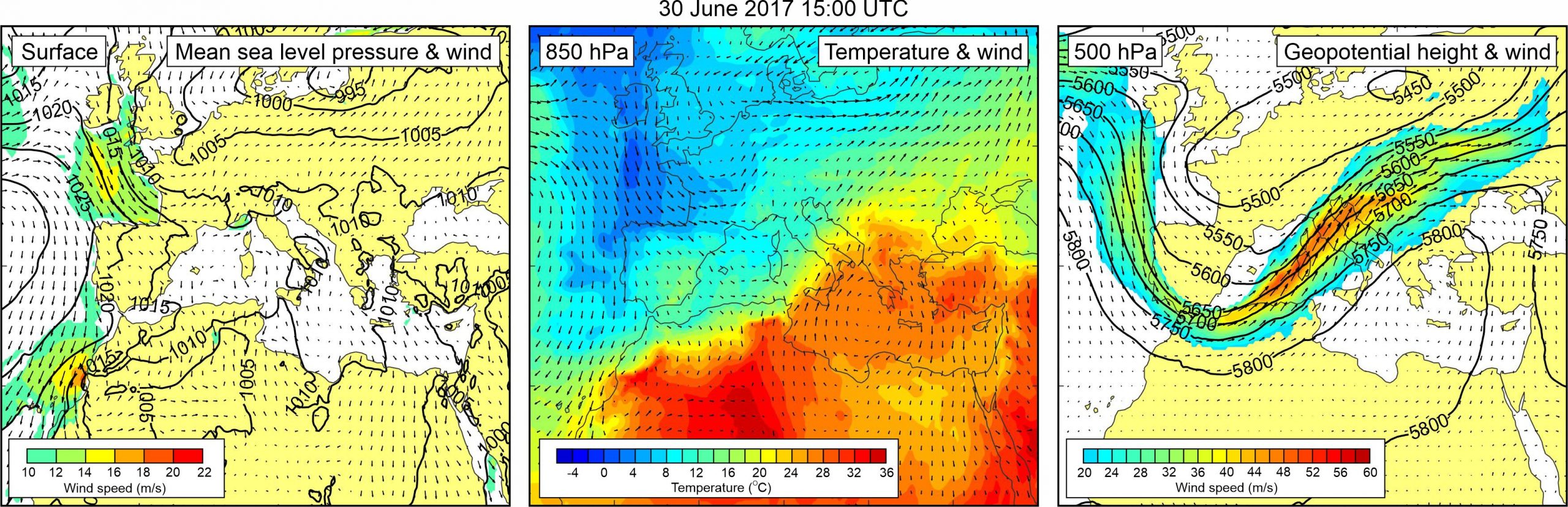
Figure 1. Synoptic situation at the time of the event: (left) mean sea level pressure and 10-m wind; (middle) temperature and wind at 850 hPa; (right) geopotential height and wind at 500 hPa.
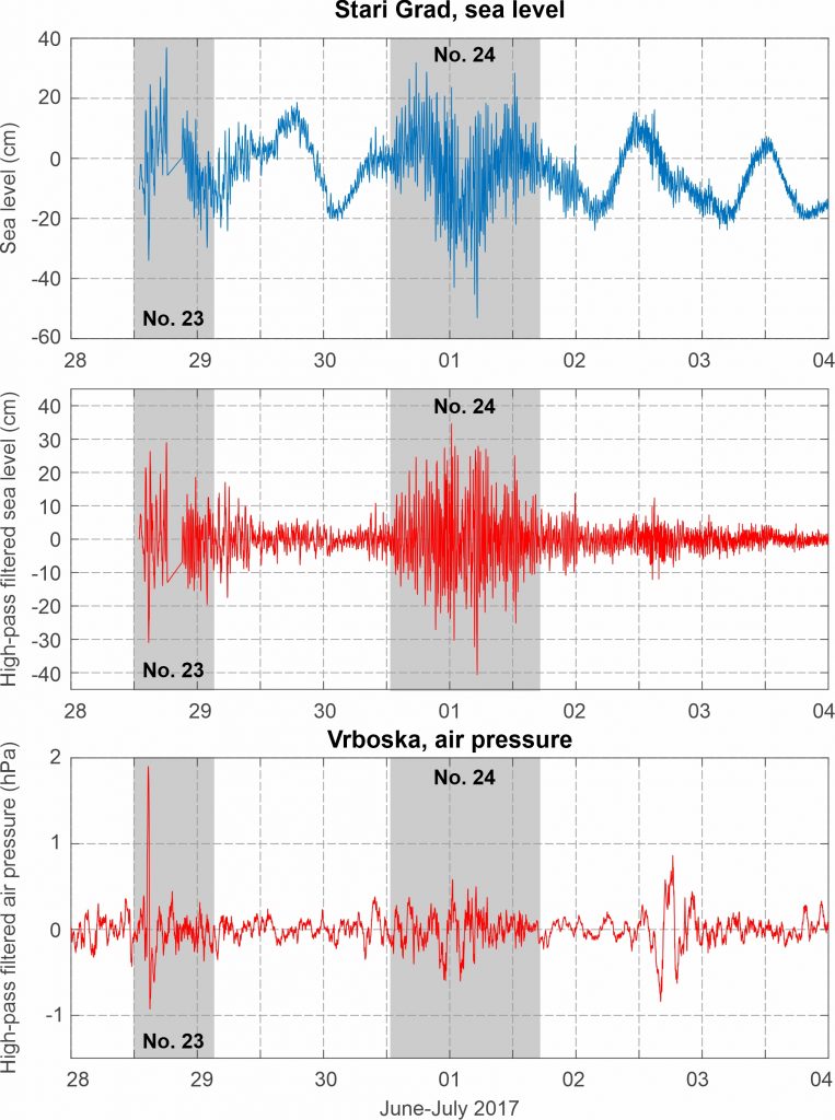
Towns of Stari Grad and Vrboska were hit by meteotsunami waves during 30 June – 1 July 2017. Information describing sea level variability and compilation of eyewitness videos were collected and posted on-line by “Dalmacija Danas” reporters (Dalmacija Danas, 1 July 2017). In addition, sea level oscillations in Stari Grad were recorded at tide gauge station, and air pressure oscillations at meteorological stations in both Stari Grad and Vrboska. According to tide gauge data, high-frequency sea level oscillations in Stari Grad started around 15:00 UTC on 30 June 2017 and lasted till 17:00 UTC on 1 July 2017. Maximum water level was recorded at 18:30 UTC on 30 June 2017, at the time of high tide, whereas maximum wave height of oscillations of 68.7 cm was recorded at 6:20 UTC on 1 July 2017. Period of sea level oscillations varied between approximately 10 and 30 min.
Available videos suggest that maximum water level was even higher at the top of the bay, where promenade was completely flooded, and where strong currents related to advancing (and retreating) sea developed. These currents carried containers, big flower pots, chairs from cafes, etc. Data from Stari Grad meteorological station reveals that high-frequency air pressure oscillations, characterized by maximum heights of 1.3 hPa, and maximum rates of air pressure change of 1 hPa/5 min, were persistent throughout the period of increased high-frequency sea level activity, i.e. from afternoon hours of 30 June till afternoon hours of 1 July. As for Vrboska, eyewitness reports and videos suggest that intense high-frequency sea level oscillations started around 23:00 UTC on 30 June, reaching maximum height around 00:30 UTC on 1 July, and persisting, with somewhat lower intensity, for a better part of 1 July.
According to videos, maximum wave height of sea level oscillations in Vrboska was at least 1.5 m, as at some point in time, a better part of inner harbor was left without water, only to be flooded a few minutes later, with water level reaching height of up to 20 cm over promenade. Videos suggest that period of sea level oscillations was between 5 and 10 min. Much like in Stari Grad, intense high-frequency air pressure oscillations lasted from afternoon hours of 30 June till afternoon hours of 1 July, reaching maximum heights of 1 hPa, and maximum rates of air pressure change of 0.3 hPa/5 min.
Atmospheric and sea level component of the event were also numerically modelled using AdriSC modelling suite (using the Weather Research and Forecast model for the atmospheric component and ROMS/ADCIRC model for the ocean component), by Denamiel et al. (2019a, 2020).
A mid-latitude cyclone was centered over the northern Europe. Over the Mediterranean, mean sea level pressure field was relatively uniform (1010-1015 hPa). Over the Adriatic Sea, surface winds were weak. At the 850 hPa level, a warm air mass was advancing from the western Sahara across the Eastern Mediterranean to the Adriatic Sea and further into the continental Europe. As a result, an upper-level temperature front developed over the Adriatic. At the 500 hPa level, a deep trough was located over the western Mediterranean and the Adriatic Sea. At the front side of this trough, exceptionally strong mid-tropospheric winds (up to ~55 m/s) were blowing over the western Mediterranean and the Adriatic Sea.
Figure 2. Original and high-pass (T < 4h) sea-level time series measured at Stari Grad, and high-pass filtered (T < 4 h) air pressure time series measured at Vrboska, all during Event 23 and Event 24.