(22) Vela Luka, Rijeka dubrovačka, Stari Grad, Vrboska, Viganj, Ston, 25-26 June 2014
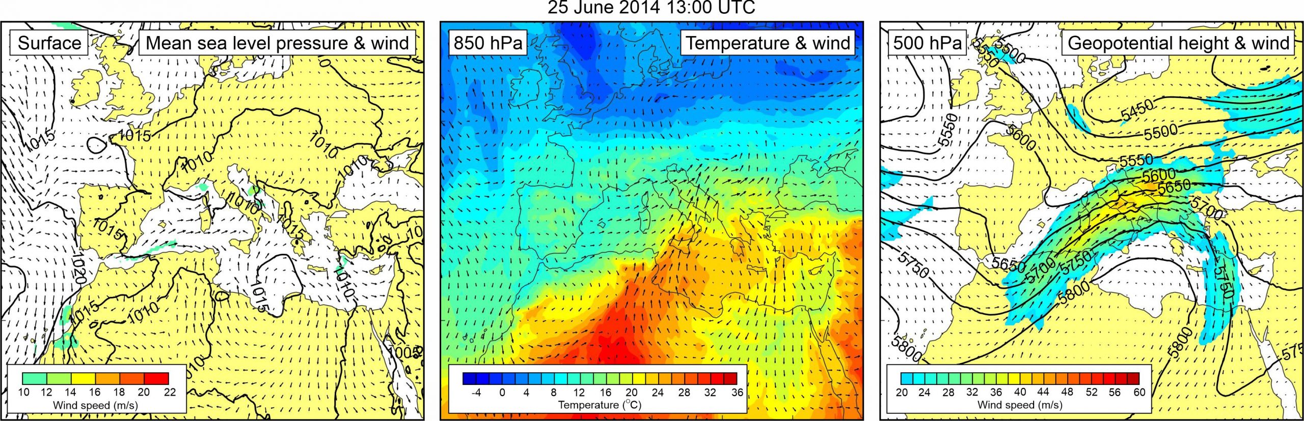
Figure 1. Synoptic situation at the time of the event: (left) mean sea level pressure and 10-m wind; (middle) temperature and wind at 850 hPa; (right) geopotential height and wind at 500 hPa.
The Adriatic multi-meteotsunami event of 25-26 June 2014 was a part of a chain of meteotsunami events which hit the Mediterranean and Black Seas during 23-27 June 2014 (Šepić et al., 2015a). Meteotsunamis were particularly numerous on 25 and 26 June in the Adriatic Sea, where at least six harbors and bays were stricken by powerful waves.
Strongest Adriatic event occurred in Vela Luka, where waves reached height of ~3 m. Event in Vela Luka started around 06:00 UTC on 25 June and lasted throughout the morning and early afternoon hours. Later the same day, around 12:30 UTC, waves with height of ~2.5 m, accompanied by ~5 m/s currents, hit Rijeka dubrovačka. In the afternoon hours meteotsunami waves appeared in Stari Grad, reaching maximum wave height of ~1 m around 13:00 UTC, and in Vrboska, reaching maximum wave height of ~1.5 m around 15:00 UTC. In both Vrboska and Stari Grad oscillations lasted throughout the afternoon and evening hours. Viganj and Ston were hit by meteotsunami waves one day later around 12:00 UTC. Oscillations at these two towns were weaker, reaching maximum height of 0.8 and 1 m, respectively.
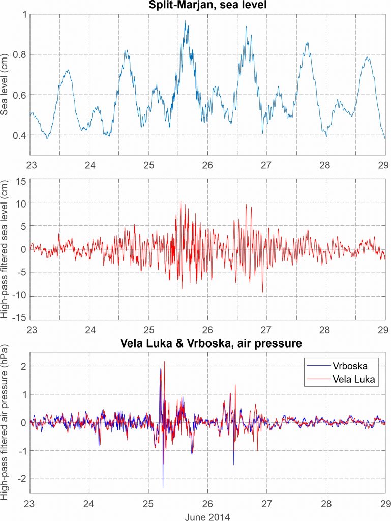
Herein we show sea level measurements from Split-Marjan. Intensification of high-frequency sea level activity can be noticed both on 25 and 26 June 2014. Air pressure measurements from Vela Luka and Vrboska microbarograph stations reveal that a series of small air-pressure perturbations propagated over the area during the two days in question.
Information on maximum wave heights and onset times were collected from eyewitnesses and presented in Šepić et al. (2016). Šepić et al. (2016) also collected sea level data from available Adriatic tide gauges (9 Italian, 5 Croatian and 2 Montenegrin), and air pressure data from 39 atmospheric stations, located mostly on the Croatian coast of the middle Adriatic. Intensification of high-frequency sea level activity was seen at all tide gauges located in the middle and south Adriatic, whereas no intensification was noticed in the northern Adriatic. Same holds for air-pressure oscillations. Ocean component of the event was modelled using barotropic SCHISM model forced by both synthetic air pressure time series, and by air pressure time series measured at Vela Luka and Vrboska atmospheric stations. Oceanographic model was able to reproduce intensification of sea level activity at hit locations; however, their exact timing and wave heights were not reproduced properly. It was shown that meteotsunamis occurring at various parts of the coast were generated by a number of atmospheric pressure disturbances of limited spatial dimensions (O(20-30 km)) and duration (O(10-60 min)). Nature of numerous atmospheric pressure disturbances was later studied by Horvath et al. (2018) who modelled atmospheric part of the event (only for 25 June) using Weather and Research Forecast (WRF) model. It was shown that the middle Adriatic Sea was traversed by a series of tsunamigenic atmospheric pressure disturbances related both to ducted atmospheric gravity waves and to convective activity, i.e. to wave-CISK processes.
Atmospheric and sea level component of the event were also numerically modelled using AdriSC modelling suite (using the Weather Research and Forecast model for the atmospheric component and ROMS/ADCIRC model for the ocean component), by Denamiel et al. (2019a, 2020).
A mean sea level pressure field was relatively uniform over the Mediterranean and Europe, with no pronounced surface pressure gradients. Nonetheless, moderate sirocco wind blew over the central Adriatic Sea. At the 850 hPa level, a tongue of warm air was advancing from the central Sahara across the central Mediterranean to the Adriatic Sea. At the 500 hPa level, a ridge was located over the Mediterranean. At the rear side of this ridge, strong mid-tropospheric winds (up to ~40 m/s) were blowing over the western Mediterranean and the Adriatic Sea.
Figure 2. Original and high-pass (T < 4h) sea-level time series measured at Split-Marjan, and high-pass filtered (T < 4 h) air pressure time series measured at Vrboska and Vela Luka, all during Event 22.