(17) Stari Grad, Mali Ston, 27 June 2003
This is another case in which Stari Grad was affected more than Vela Luka, and it is one of the few Adriatic events that are well studied. The event is described in three newspaper articles (Slobodna Dalmacija, 28 June 2003; Večernji list, 28 June 2003; Vjesnik, 28 June 2003) in which it is stated that “the large tidal wave, which on the Friday morning at about six o’clock flooded the Stari Grad waterfront and even a wider area of the Vorba Park, resulted in enormous damage to the inhabitants of this old town… After the first tidal wave followed an even larger one, unseen up to now in Stari Grad. Its height was ca. 1 m above the columns, which was really frightful, and the wave resulted in vehicles being literally redistributed on the Stjepan Radić Square… While receding, the tidal wave dragged along a wall, having the length of almost 60 m and the height larger than 2 m, whereupon the wall collapsed into the canal.”
It is also mentioned in the articles that “on Friday between 7:30 and 9 hours a large tidal wave occurred in Mali Ston Bay. After the large water mass receded, strong currents literally swept away shellfish farm in the area between Mali Ston and Cape Nedilja close to Stonska Duba at a length of about six nautical miles.”
The event was also recorded by four tide gauges in the area (Split, Sućuraj, Ploče and Dubrovnik), albeit with the amplitudes much smaller than in Stari Grad and Mali Ston (Vilibić et al., 2004).
This event was successfully reproduced by an oceanographic model that was forced by the observed air-pressure perturbation propagating above the sea (Vilibić et al., 2004). It turned out that the small air-pressure forcing, which did not surpass a few millibars, could have supported the sea-level and current variability indicated by the observations in Stari Grad and Mali Ston Bay, respectively. Moreover, the model results were consistent with the data recorded by the four tide gauges. The meteorological aspect of the event was studied – using observations and modeling – by Belušić et al. (2007). They found that the air-pressure perturbation was related to a mesoscale convective system, which had been triggered above the Alps and then propagated toward the southeast (i.e., along the East Adriatic coast).
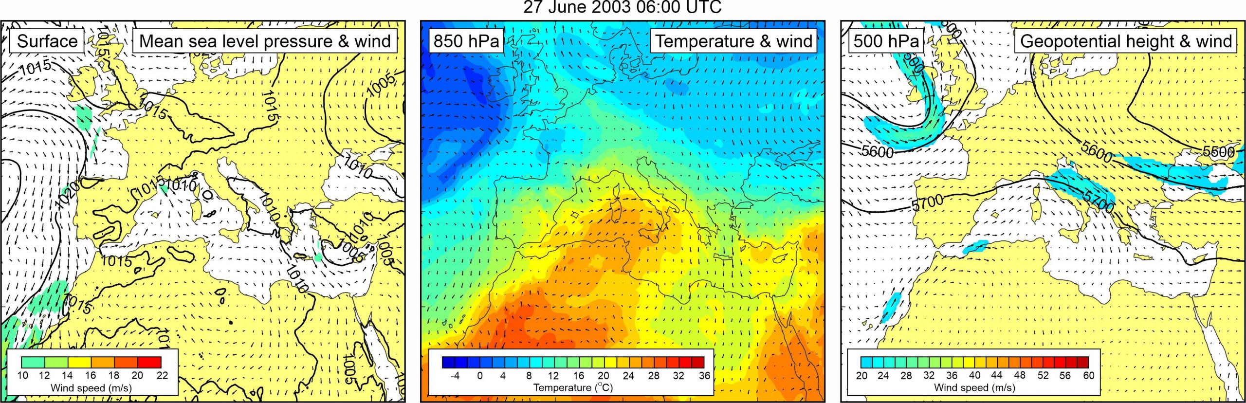
Synoptic situation observed during the 27 June 2023 meteotsunami event is somewhat atypical. Mean sea level pressure field was relatively uniform over the Mediterranean, resulting with only weak surface winds over the Adriatic. At the 850 hPa level, a tongue of warm air was advancing from the western Sahara towards the Adriatic Sea. Peculiarity of the situation is revealed at the 500 hPa height, where northwesterly wind of ~20-25 m/s was blowing over the Adriatic Sea. The synoptic situation was also analysed by Vilibić and Šepić (2009).