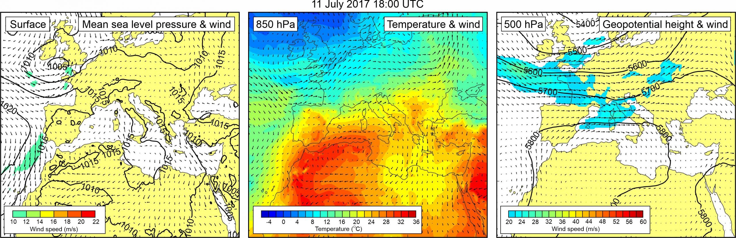
Figure 1. Synoptic situation at the time of the event: (left) mean sea level pressure and 10-m wind; (middle) temperature and wind at 850 hPa; (right) geopotential height and wind at 500 hPa.
Several locations on the island of Lošinj were hit by meteotsunami waves between 18:00 and 19:00 UTC on 11 July 2017. These locations are: (1) bay Krivica, (2) bay Čikat, and (3) town of Mali Lošinj. Event was strongest in bay Krivica where about 20 leisure boats were moored. According to eyewitnesses, sea suddenly retreated from the bay around 18:00 UTC, leaving uppermost 30 m of the bay length completely dry (Burza nauzike, 27 July 2017). As a result, numerous boats were stranded on the dry sea bottom. A few minutes later, a big “tidal wave” brought sea back to the bay ejecting some of the boats on the coast. Strong sea currents moved cement mooring blocks from the sea bottom. Altogether, three pronounced waves were observed within a 15-min period, yielding an approximate period of oscillations of ~5 min.
Waves in the bay of Čikat were filmed by a YouTube user jedro43 (YouTube, 12 July 2017a). Although, the event was not as dramatic as in Krivica bay, the video depicting it is very professional and gives us valuable information on the event. During 5:33 min of video, sea advanced and retreated 3 times, yielding an approximate period of oscillations of ~2-3 min. Height of sea level oscillations (detectable from harbor structures and author’s comments) was ~1 m. Finally, event was also strong in the town of Mali Lošinj, where sea arose over promenade flooding numerous cafes, shops, and local museum. Flooding of Mali Lošinj was filmed by a YouTube user Dule 1950 (YouTube, 12 July 2017b). According to eyewitnesses, the event was accompanied by a strong thunderstorm, rain and winds of up to 40 knots.
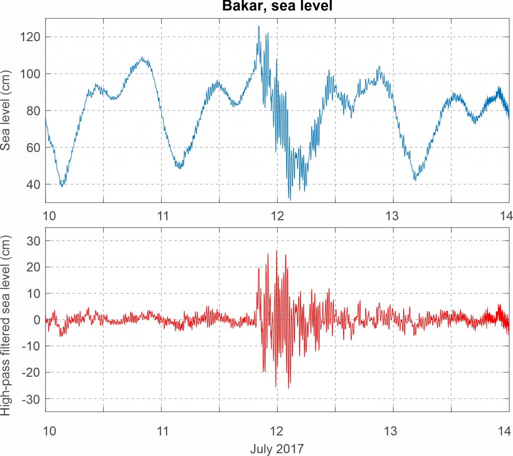
An increase in high-frequency variability was also recorded by the ~80 km distanced Bakar tide gauge. High-frequency sea level oscillations in Bakar were intensified from ~19:00 of 11 July till ~04:00 UCT of the following day. The maximum oscillation with a 51.5 cm crest-to-trough height was recorded around midnight of 12 July.
Atmospheric and sea level component of the event were also numerically modelled using AdriSC modelling suite (using the Weather Research and Forecast model for the atmospheric component and ROMS/ADCIRC model for the ocean component), by Denamiel et al. (2019a, 2020).
The synoptic situation during the event was characterized by weak pressure gradients over the Mediterranean and most of Europe, and corresponding weak surface winds. At the 850-hPa level, warm air was advancing from the western Sahara across the western Mediterranean towards the Adriatic Sea and the southeastern Europe. Upper-level temperature gradients were present over the Adriatic Sea. At the 500 hPa level westerly mid-tropospheric winds with speeds up to 28 m/s were blowing over the western Mediterranean and the northern Adriatic.
Figure 2. Original and high-pass (T < 4h) sea-level time series measured at Bakar during Event 25.