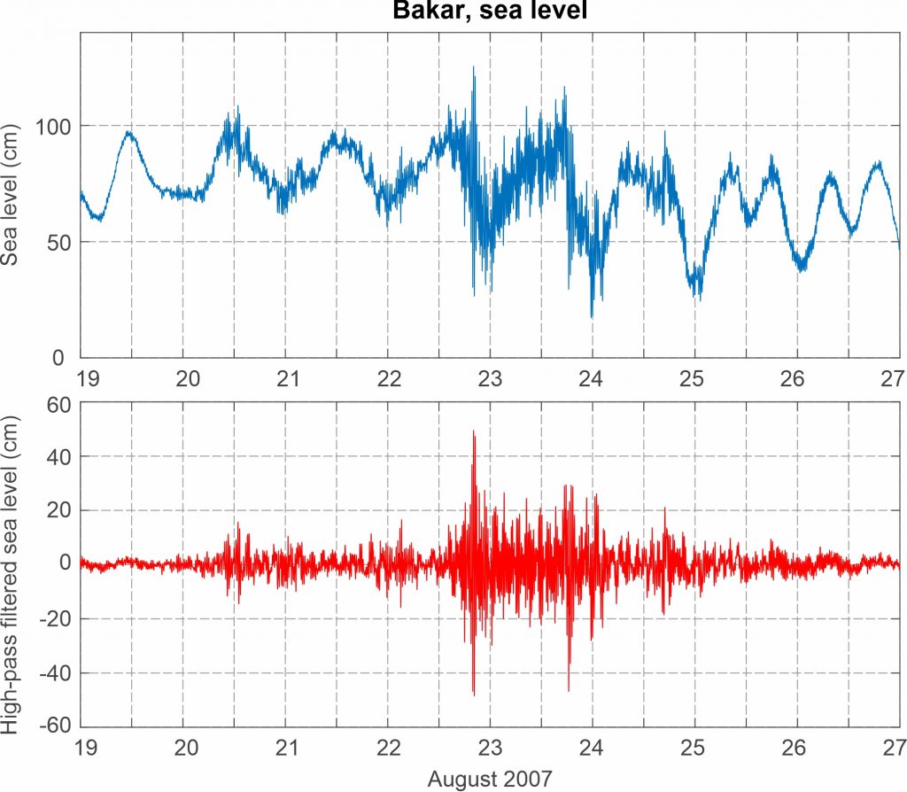
Figure 1. Synoptic situation at the time of the event: (left) mean sea level pressure and 10-m wind; (middle) temperature and wind at 850 hPa; (right) geopotential height and wind at 500 hPa.
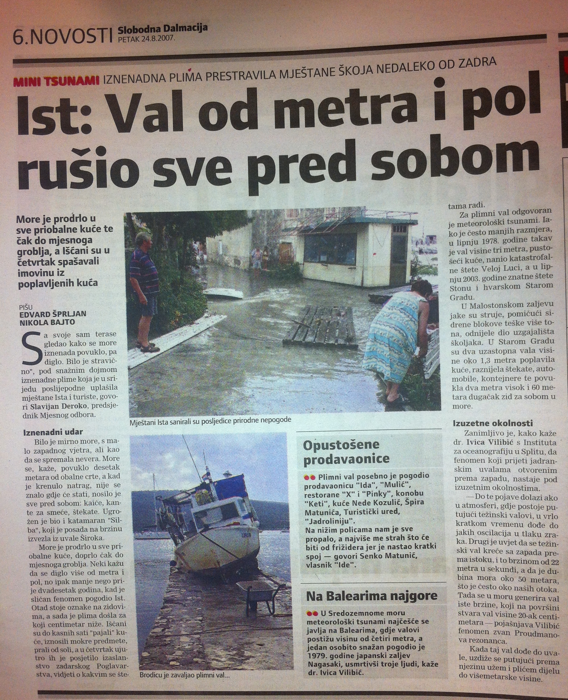
Information on the event is based on data collected during the author’s visit to the island of Ist on 24 August 2007. It is interesting that the event also manifested itself in pronounced seiching on the nearby island of Molat where the author vacationed at the time.
Additional descriptions of the Ist event may be found in several newspaper articles (Večernji list, 24 August 2007; Jutarnji list, 24 August 2007; Slobodna Dalmacija, 24 August 2007) and in the paper authored by Vilibić and Šepić (2009). The newspaper reports are typical: one of them cites an eyewitness who testified that “during the whole day there were some light thunderstorms, but at the time of the tidal wave there was a complete calm, without a breath of wind. Suddenly, in a few seconds, the sea receded some 10-15 m from the coast so that many boats hit the bottom, whereupon some boats were carried to the land by the returning high tidal wave.”
The cause of the event was studied in detail by Šepić et al. (2009), and it was found that a few-millibar air-pressure perturbation propagated above the area at a speed of approximately 21-24 m/s. The speed turned out to be almost identical to the speeds previously determined for the 1978 event in Vela Luka (Orlić, 1980) and the 2003 event in Stari Grad (Vilibić et al., 2004). Idealised numeric simulations, covering the broader northern Adriatic, area were performed by Šepić et al. (2015b), and a higher resolution modelling, using ADCIRC with included flooding and drying algorithm, by Bubalo et al. (2021).
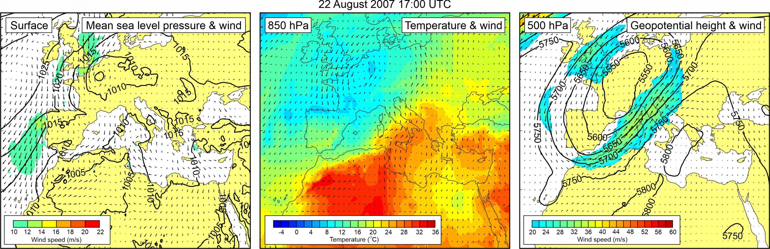
Sea level measurements from the ~120 km distanced Bakar tide gauge station revealed increased high-frequency activity at the time of Ist meteotsunami, with the short period sea level oscillations reaching almost 100 cm at ~20:00 UTC, some 4-5 hours after peak oscillations in Široka Bay.
Synoptic situation over Europe during the 2022 Ist meteotsunami is reminiscent of the situation during the 1984 Ist meteotsunami (Event 15). A weak pressure low was centered over the northwest Europe, but with no pronounced pressure gradients to the south and east of it. Thus, surface winds over the Mediterranean were weak. At the 850 hPa level, a tongue of warm air was advancing from the western Sahara, across the central Mediterranean to the Adriatic Sea. As a result, a temperature front developed over the Adriatic Sea. At the 500 hPa height, a distinct closed low was centered over the northwest Europe, at its front side, strong southwesterly upper level winds (up to ~35 m/s) were blowing over the western Mediterranean and the Adriatic Sea. The synoptic setting is also discussed by Vilibić and Šepić (2009) and by Šepić et al. (2009).
Figure 2. Original and high-pass (T < 4h) sea-level time series measured at Bakar during Event 19.