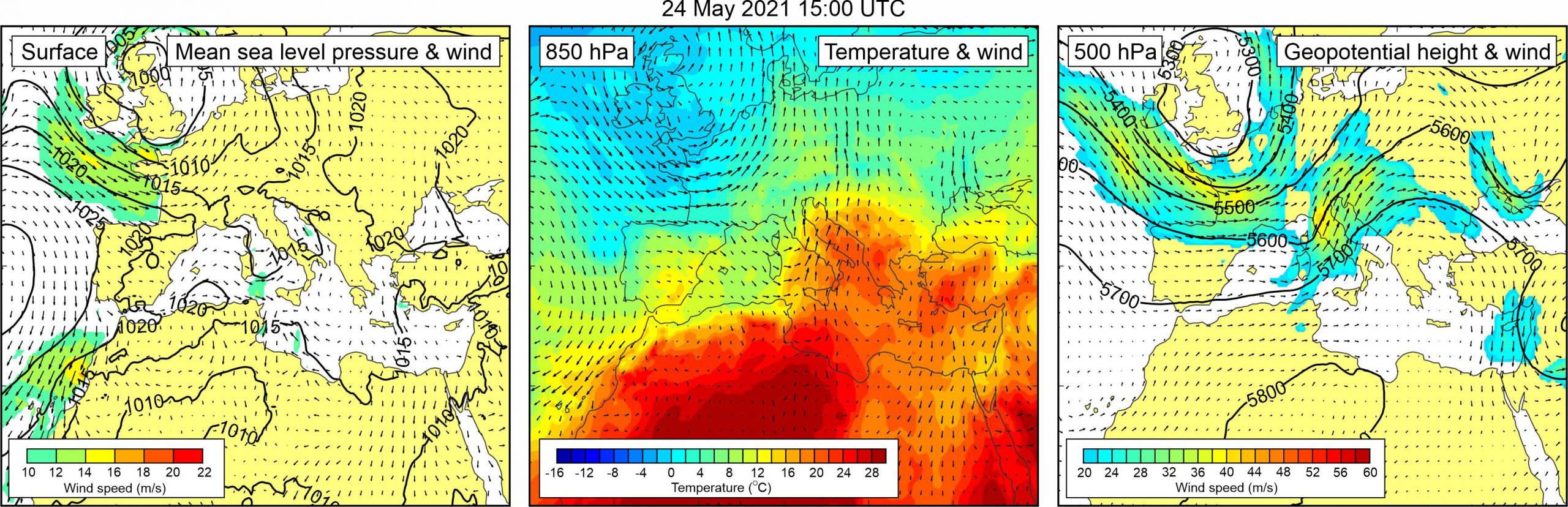
Figure 1. Synoptic situation at the time of the event: (left) mean sea level pressure and 10-m wind; (middle) temperature and wind at 850 hPa; (right) geopotential height and wind at 500 hPa.
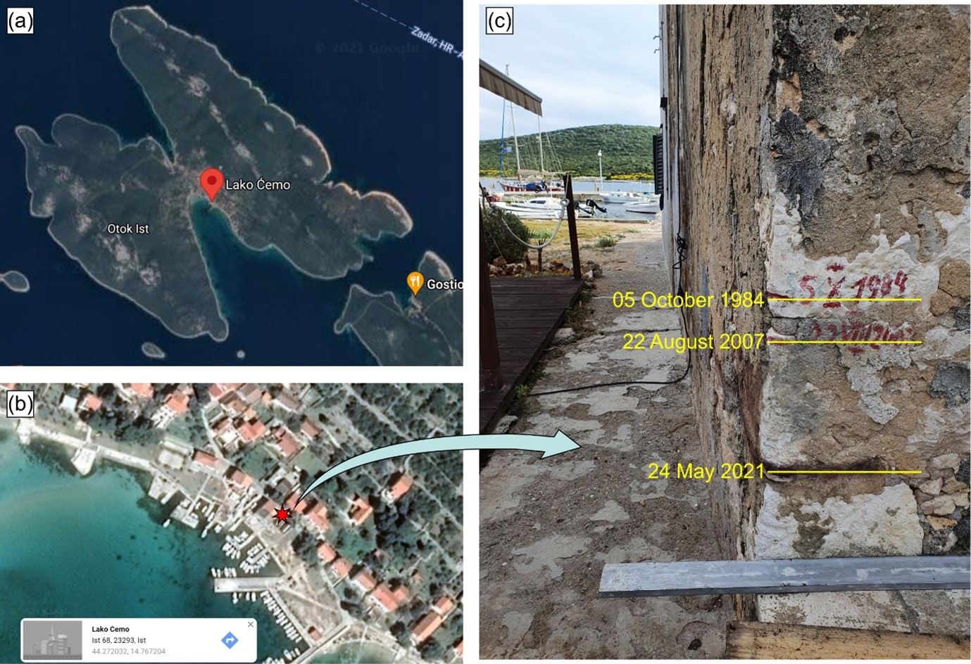
The Široka Bay meteotsunami of 24 May 2021 is the third strongest meteotsunami to hit Široka Bay during the last 40 years. According to newspaper and interviews that Jadranka Šepić had with residents, the event, which started around 15:30 UTC, was characterized by sea-level oscillations of 2-3 m. According to marks on the one of the coastal houses, the maximum level which the sea reached was 30 to 40 cm lower than during the 1984 and 2004 Široka Bay events (Event 15 and Event 19, respectively). Eyewitnesses claim that period of waves was 3-5 min, and that harbour was hit by six strong waves, of which three were of approximately same destructive height.
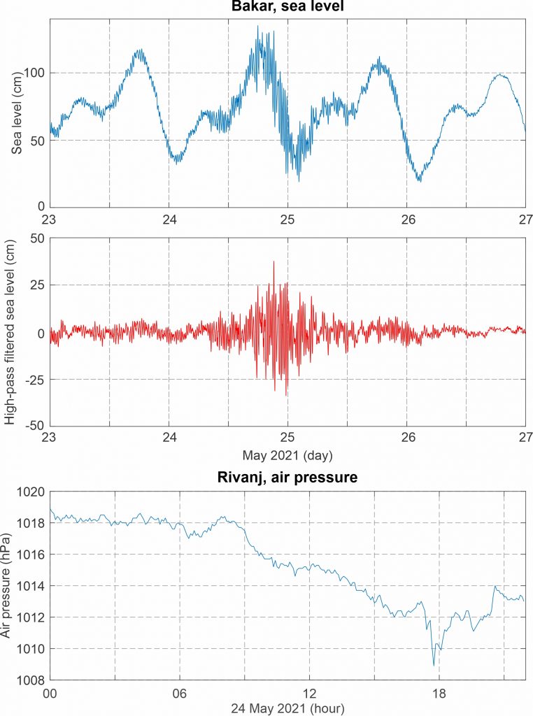
The event caused some destruction, both to boats, and to nearby coastal properties, and a fire brigade and volunteers were called to the Island a day after the event to help pump the water out of the coastal houses and to clear the litter. According to the meteorological data from the ~23 km distanced Island Rivanj (the Croatian amateur meteorological network Pljusak station), the event was likely associated to a very strong atmospheric pressure disturbance of 4.1 hPa height which propagated over the area between 17:10 and 17:45 UTC, i.e. close to the time of the event. An increase of high-frequency variability was detected at the ~120 km distanced Bakar tide gauge station. Short period sea level oscillations were intensified from the evening hours of 24 May till the early morning hours of 25 May, reaching maximum crest-to-trough height of 68.8 cm around 21:15 UTC.
It is interesting that on the same day, a meteorological tsunami was also recorded on Corsica (InMeteo, 25 May 2021), pointing to a possible Mediterranean meteotsunami chain similar to the one from June 2014 (Event 22 in our catalogue) when meteotsunamis hit 4 locations (from the western Mediterranean to the Black Sea) within a 5-day period.
Synoptic analysis reveals that a field of slightly lowered mean sea level pressure was positioned over the northern Adriatic. At the 500 hPa height, warm air mass was advancing from western and central Sahara, across the central Mediterranean towards the Adriatic Sea and further into the continental Europe. As a result, an upper level temperature front was present over the Adriatic Sea. At the 500 hPa height, strong south-westerly to north-westerly winds blew over the middle and northern Adriatic.
Figure 2. Original and high-pass (T < 4h) sea-level time series measured at Bakar, and high-pass filtered (T < 4 h) air pressure time series measured at Rivanj, all during Event 35.
Figure 3. (a) Google Maps photo of Ist island and Široka Bay; location near the pin is zoomed-in in (b); red star in (b) points to location of the wall at which maximum sea levels during three Široka Bay meteotsunamis are marked by residents – shown in (c).