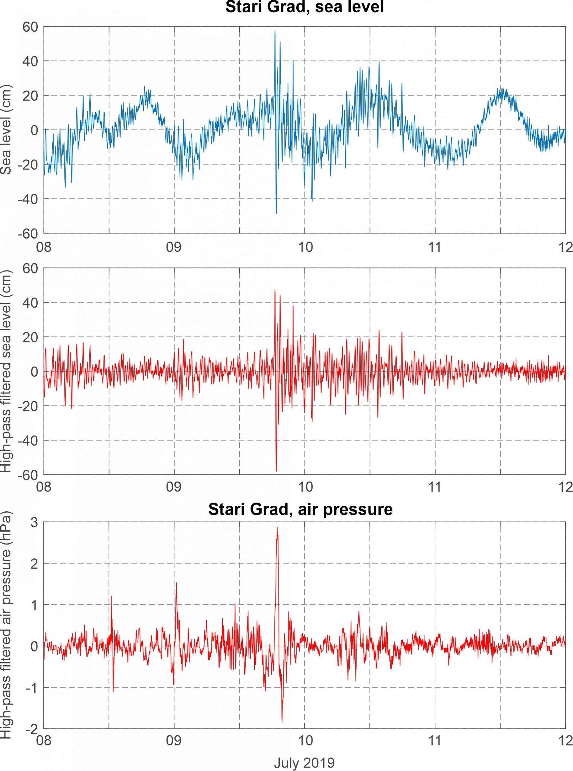
(28) Stari Grad, 9 July 2019

According to the atmospheric measurements done over the middle Adriatic, the event was generated by a pronounced air pressure disturbance, characterized by a min-to-max height of 3.6 hPa, maximum rate of air pressure change of -1.7 hPa/5 min, and a total duration of approximately 1 hour. The atmospheric disturbance propagated across
the Adriatic from the Italian (Ancona, Vieste) towards the Croatian (Vis, Stari Grad) coast traversing Stari Grad between 18:15 and 19:15 UTC. Onset of high-frequency sea-level oscillations was simultaneous to the arrival of the air pressure disturbance, with the sea-level oscillations enduring for almost a day. The most pronounced sea wave had a height of 105.3 cm at the tide-gauge site. It reached its maximum height of 47.3 cm at 18:31 UTC, and its minimum height of -58.0 cm at 18:47 UTC. A period of sea-level oscillations was 20-30 min. The maximum total sea level of 57.5 cm was recorded at the same time as the maximum of the meteotsunami wave, i.e. at 18:31 UTC, with most of the recorded height related to the contribution of the meteotsunami wave. The 9 July 2019 event is also discussed in Denamiel et al. (2019b), in which it is used as one of the test cases for validation of the meteotsunami module of a real-time one-way coupled atmosphere-ocean AdriSC model.
Event is also described in an online article (Dalmacija Danas, 9 July 2019) where it is said that the sea retreated for more than a meter in around 10 minutes.
Synoptic analysis reveals that a field of slightly lowered mean sea level pressure was positioned over the Adriatic. At the 850 hPa height, a warm air mass was advancing from the western Sahara across the western Mediterranean towards the Adriatic Sea. At the 500 hPa height, strong westerly to north-westerly winds, associated to an upper level ridge, blew over the middle Adriatic.
