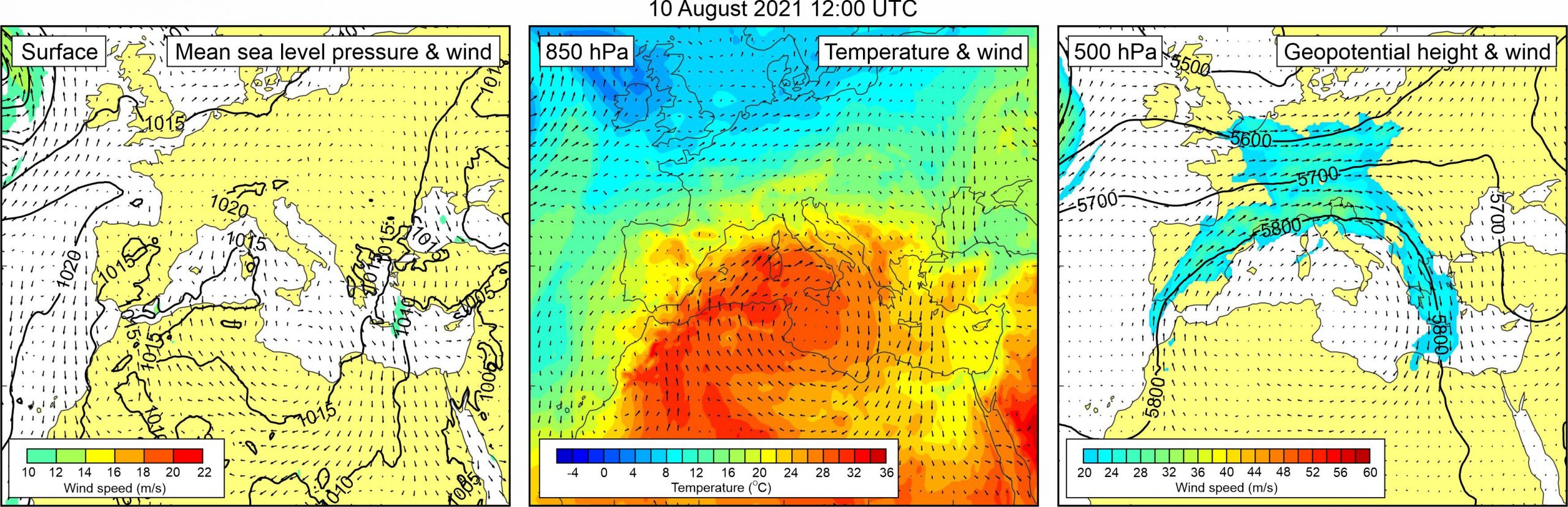
Figure 1. Synoptic situation at the time of the event: (left) mean sea level pressure and 10-m wind; (middle) temperature and wind at 850 hPa; (right) geopotential height and wind at 500 hPa.
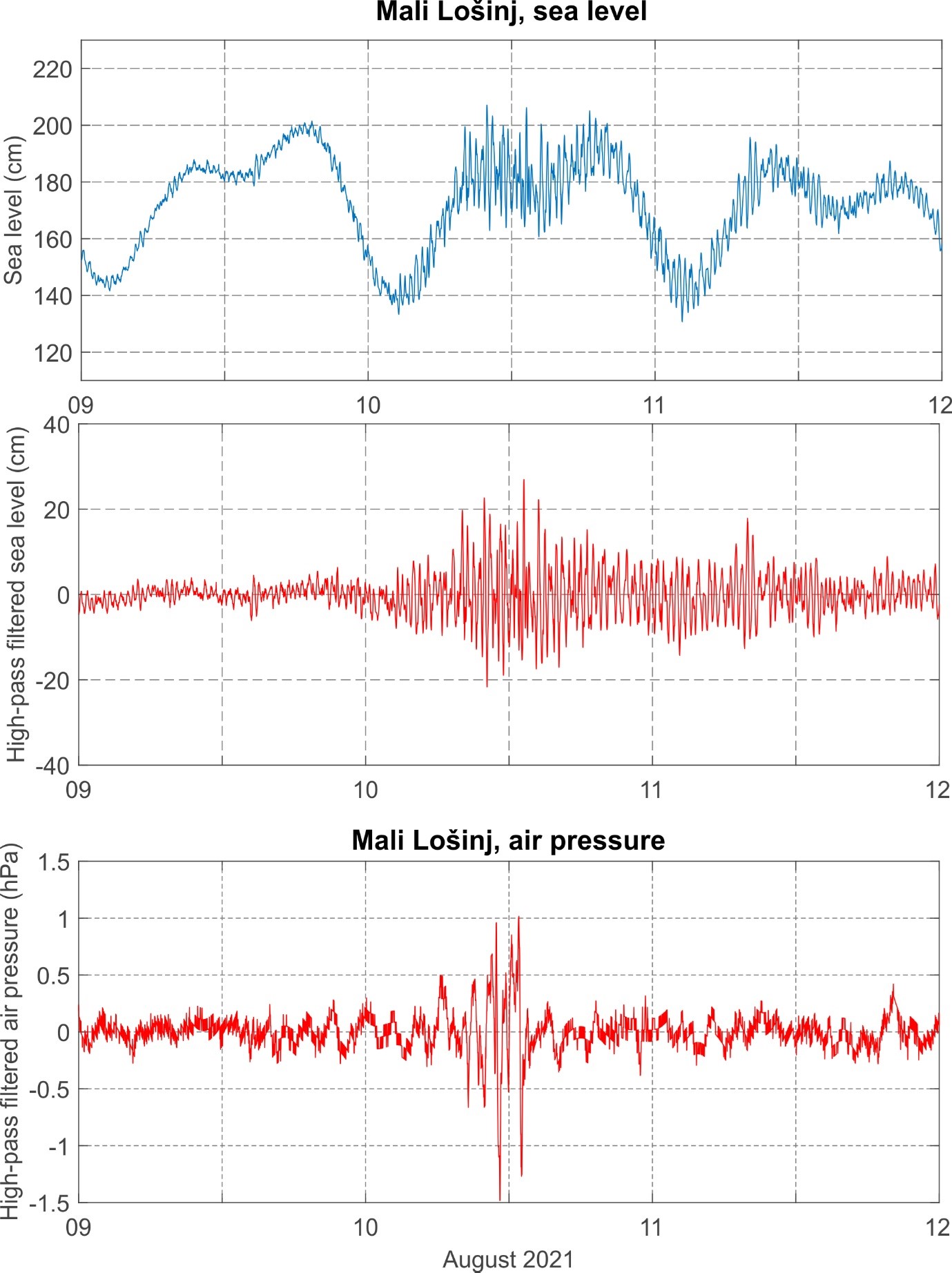
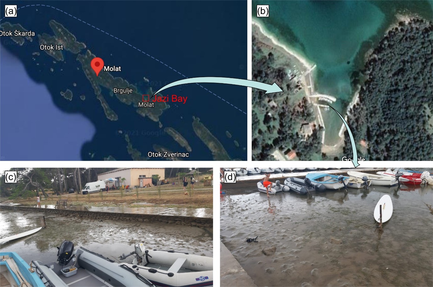
According to eyewitnesses’ reports (given to Mirko Orlić), a weak meteotsunami occurred in Jazi Bay, located on the northern coast of Molat Island between 12:00 and 14:00 UTC of 10 August 2021. Sea level oscillations had a period of approximately 5 minutes and lasted for 2 hours. During the sea retreat phase, boats were left stranded at the sea bottom, much like the fishes which were then collected by the residents, and during the high sea level, sea reached the coastal road, amounting to a total height of oscillations of approximately 1 m. Information on the event and photos were kindly provided by Ivan and Marina Šarunić from Rijeka, Croatia. Sea level measurements from Mali Lošinj (50 km to the northwest) reveal that high-frequency sea-level oscillations were present over the wider area. At Mali Lošinj these oscillations intensified around 8:00 UTC, with the highest wave (42.7 cm) measured between 13:05 and 13:22 UTC, i.e. at the time of the Molat event. The sea oscillations were simultaneous to the train of air pressure disturbances which passed over Mali Lošinj between 8:36 and 13:43 UTC. The atmospheric train consisted of five strong oscillations, of which the strongest one had a height of 2.4 hPa and a period of 25 min. Maximum 5-min rate of air pressure change at Mali Lošinj was 1.6 hPa/5 min and was recorded at 12:56 UTC, shortly before the strongest wave.
It should be noted that in the afternoon hours of the same day (around 16:00 UTC), high-frequency sea level oscillations resulting in a weak flooding (lower than 1 m) were also observed in Vrboska on Hvar Island during their local St. Lovre feast. The information was given to Jadranka Šepić by eyewitnesses. Although the event in Vrboska was not strong enough to be classified as a meteotsunami, it does points to the intensification of high-frequency sea level activity over even wider area (Vrboska is ~185 km to the southeast of Molat Island) during most of 10 August 2021, as well as to a presence of meteotsunamigenic synoptic conditions. Air pressure data from the IOF measurement network reveals that air pressure disturbances of variable strength travelled over the middle Adriatic Islands (Vis, Hvar and Brač) during most of 10 August. The strongest atmospheric disturbance of 2.8 hPa height (not related to the one causing meteotsunami at Molat) was recorded in Vrboska between 18:30 and 19:00 UTC; the corresponding maximum 5-min rate of air pressure change was 1.2 hPa/5 min. At nearby Stari Grad and Vis tide gauge stations, intensified high-frequency sea level oscillations occasionally reaching maximum heights of ~35 and ~50 cm, respectively, were observed throughout the day.
During
the Molat event, a uniform field of surface pressure (1015-1020 hPa)
complemented by weak surface winds was present over most of the Europe. At the
850 hPa level, warm air mass was advancing from western Sahara across the
western Mediterranean towards the Adriatic Sea, resulting with pronounced upper
level temperature gradients over the Adriatic Sea. At the mid-troposphere
height strong winds were blowing around the closed high which was centred over
the northern Africa and western Mediterranean. The 500-hPa level wind of
western to north-western direction was particularly strong over the Adriatic
Sea. These upper-level winds were roughly aligned with the Jazi Bay, i.e. blew
towards its entrance.
Figure 2. Original and high-pass (T < 4h) sea-level time series measured at Mali Lošinj, and high-pass filtered (T < 4 h) air pressure time series measured at Mali Lošinj, all during Event 34.
Figure 3. (a) Google Maps photo of Molat island with a zoom-in to (b) Jazi Bay; (c) and (d) photos taken at Jazi bay during the low water. Photos were taken by Ivan and Marina Šarunić from Rijeka, Croatia.